Only a short note this time: I just added a widget to the sidebar that shows my recent photos. I got a Nikon D5000 about one month ago, so I hope to update this regularly with amazing photos 😉
May Update
After I wrote my last blog-post I had a lot of weeks full of work and travelling. As result of this I had no time to write anything new here. Now I just want to sum up the events of the last weeks.
After my girlfriend left Glasgow I had to finish some reports and assignments for the university. In the last two weeks of april we had to hand them in and for some classes we had to present our work.
For the first week in may I was in Germany to celebrate the wedding of my cousin. In the week I’ve been at home I also visited my girlfriend in Erfurt, where she worked at this time. There I shot a view pictures and videos to review her great new Canon IXUS 115. I uploaded these pictures and videos on my website and as youtube video.
After coming back to Glasgow I had to study for the last exams here. A totally new experience was to program complete VHDL programs on paper or to purely remember loads of formulae or how data transmission protocols (TCP,RTP) work including a lot of details about them.
By reading hackaday I got some new ideas for hiding information in audio files which I used to write a python script. This is just a fun-thing for challenging other people by mystery geocaches for example. Probably I will do one with this technique when I’m back at home.
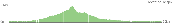
Falls of Glomach
I had 4 visitors for the first weekend in April – my girlfriend, my cousin, her boyfriend and his sister. Together we went to have a hike at the Falls of Glomach, which is next to the bridge to the Isle of Skye (see map below).
I was worried about the weather again – but this time we had a lot of luck! It was just a little rainy but also a long time we had really warm sunshine.
The Falls of Glomach are supposed to be the highes or at least one of the highest waterfalls in the UK at 113m. It is a really fantastic scenery once you made the medium hard walk to this spot.

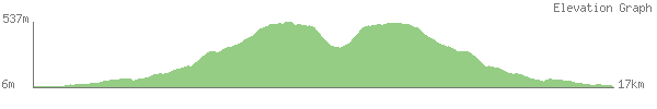
Kylerhea hills (2nd day on Isle of Skye)
On our second day on the Isle of Skye we went to the south of the island. There we wanted to walk along a nice route for a day trip. Unfortunately the weather was really bad with heavy wind and permanent rain from the side (yes, it was raining horizontally). Another problem was that a part of the group was not used to walk so much and so they were totaly exhausted from the walk the day before. One of them said “fuck you Chris” when he saw the ascend I planned to go up.
To make the trip enjoyable for all of us we decided to take another route. We decided to take a route along the foot of the hills and try to get up somewhere. When we reached one of the smaller summits the wind was directly blowing towards us and was so strong that it was even hard to go forward. At this point we decided to go back.


Unfortunately it was to rainy all the time to make more good photographs. But as usual here is the GPS-Track:
Way to Isle of Skye and first day there
In the mid of march I’ve visited the Isle of Skye. I went there with some of the other students from Leipzig, that are here with me.
On the way to Skye we had a stop at Eilean Donan Castle:

From there we made our way to Portree, which is a small nice city on the westcoast of Skye.

On our first day on the isle of skye we went to another castle, but it was closed and one could not see it from along the coast unfortunately.

Thanks to geocaching we found another nice spot next to the castle. It is called “coral beach” and it is the first thing here I would really call a beach 🙂

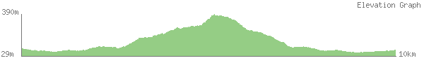
From there we headed to have a hike next to Waterstein Head on the westcoast of Skye. This part of the island has a phenomenal rocky and steep coast. Unfortunately we had not the best weather like for all the weekend. But here it was very predictable since we walked along the coast and saw the rain coming towards us 😉

Here you can see the highest part of the coast. It was really impressive!

Last but not least: the track of our walk:
You will see new posts in the next few days here. I will add pictures and the track of the second day on Skye as well as some stuff from my trip in the spring break.
Ben Vorlich
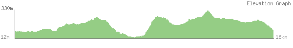
The first weekend in March I went to Arrochar, a small city next to Loch Long, wich is connected to the Atlantic Ocean. From there we walked a long way up to Ben Vorlich. Unfortunately we did not know how we can get up to Ben Vorlich on the best route. We followed a small street some meters up the hills before we went further up without a path. This was quite exhausting and also time consuming. Thus we arrived on top of Ben Vorlich quite late so that we did not come back to the train station on time. We missed the last train by almost 2 hours.
We were quite lucky to find a small restaurant next to the train station. The people there helped us to find a bed and brackfast. One of the guests showed us the way to our accommodation and he also brought us to Glasgow Airport on the next morning. Thanks to all the people who helped us this weekend!
Alltogether the trip was really nice and I think I will remember it for years!
Because of the heavy fog and clouds there are just 2 I want to show here:


This time the track is not the best. It was the first time I was using my new Garmin GPSMap 62s. Unfortunately I did not get the batteries on time so that I had to use some old ones that were empty after a short time. For the rest of the track I used my phone again but it’s battery was not completely charged and it also got empty quite early. Thus the track ends at the point where we arrived on Loch Sloy. The further route was along the Loch in southern direction and then back the way we came to the starting point.
Aberfoyle
When I planned this trip I wantes to walk along a rout of about 20km, but when we arrived there the busdriver told us that the late bus I wanted to take is not operating on sundays. Unfortunately he was wrong, what the driver of the bus we took back told us – so we shortened our route without any good reason :-/ But it still was a really nice walk and we enjoyed the weather the whole day. It was over 10°C and sunny all the time!


Clyde walkway and Clyde falls
At the second weekend of february some of my flatmates and me went to a long walk along the clyde. It’s not much to say about it – the pictures say more than 1000 words:


And here it is again: the track of our walk. It was a really long walk compared to the former trips, but it was also much flatter than ever and as the last times there was a beer waiting for us at the final destination.
Glengoyne Distillery
At the first weekend of february we visited the first distillery since we are in Scotland. We chose one of the best rated Distillery here.
The tour around the destillery was quite interesting and the whisky is really tasty!


Thanks to my flatmate Michal, who made these photographs!
Island Arran
Last weekend we went to an island for the first time since we are here in scotland. Surprisingly there were much more trees than we have seen before on other places. Unfortunately there were clouds on top of the mountain, so on top of the mountain Goatfell we could just see the next few meters. But on our way up and down we have seen a lot of great nature. Just to give you an idea here are some pictures of it:


After I used my phone again for navigation and tracking of our route i can provide you with the way we walked. Simply because of the clouds on the top we took a wrong way for going down and when we noticed this we decided to go down there further instead of going up and searching for the right way. I can’t recomend this way in general but it may be fine if you want to find your own way. Some ways that are good to walk are on openstreetmap. I added 2 new ways on the island – one at the beach and one in the valley south-west to Goatfell.